I'd never heard of inclines until one day I was wandering around the University of Cincinnati's local section and saw Melissa Kramer's book, The Inclines of Cincinnati. Cincinnati had five inclines (not all at once) hauling folks up some of our sizable hills from 1871 to 1948: Bellevue, Fairview, Mount Adams, Mount Auburn, and Price Hill. (They all also had a bunch of other names.) I have two thoughts about this: 1) This is exactly the kind of thing I was hoping to learn when I started this A to Z Challenge, so yay! and 2) Dang, I really wish these things still existed. They were already gone even before my grandma lived here as a young woman.
Here's what they looked like in action:
The Mount Adams Incline was also the star of a bunch of postcards from the era (see this and many, many more at Cincinnati Views):
I've heard that the Price Hill Incline is the only one with any kind of commemorative signage letting people know what used to be there. In fact, I-71 runs over the base of the former Mount Adams Incline, so it would have to be a pretty big sign to tell people what they're driving over. However. One of inclines was replaced by an even slower form of transport: stairs. Right here in my own neighborhood, the footprint of the Mount Auburn Incline is preserved in the form of the Main Street Steps. So naturally, I took a stroll down them. It's pretty cool, really; Main Street comes to a T in the road and the only way to continue on Main is to go up the steps.
What it looked like in the late 1800s:
 |
| Source: cincinnati-transit.net. |
 |
| I think this was on the second segment down. The steps are .17 mile long in total, according to my preferred mapping site. I'm no expert, but I'm pretty sure that's longer than your average staircase. Even if you're Tevye. |
There was a public house at the top of the hill when the Incline was in service. There's a park there now, but again--nothing to indicate whether the park was the site of Lookout House (I'm just guessing that it was), or that an Incline once ran here. I can't get over my astonishment that despite their existence being otherwise well documented, this pretty cool slice of Cincinnati history goes unremarked-upon in four out of five sites where it happened.
 |
| Mind you, people probably still drink here. Just not legally. |
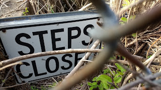
There are outdoor stairs all over the city, by the way, although I feel like I see as many "steps closed" signs as I see steps in active use. We have some hills, y'all. I imagine all the closed stairways will remain closed, given how much investment it would require to basically rebuild them.
 |
| This one is probably the saddest, although given the fence and the fact that you can't even see steps there any longer, it's also the most redundant. |
Sources: Cincinnati Views: Inclines and Cable Cars, Cincinnati Transit.


No comments:
Post a Comment